The Pillsbury Family
From Pillsbury Grange in Derbyshire, to the Colonies, to California and beyond
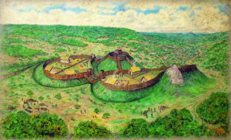
Castle Pilsbury
Illustration of Pilsbury Castle as it may have been.
Taken from the nearby signboard
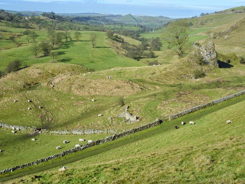
We were out walking the hills above the Dove valley near Hartington yesterday. Pilsbury Castle lies in the valley, mid way between Hartington and the tiny village of Crowdecote.
The castle is an odd place. Stuck in a remote spot at the bottom of the valley, nothing is left but the earthworks because it never had any stonework.
There are some obvious conjectures of course, but nobody seems to know for sure why the castle was built, why it was never rebuilt in stone or why it was built in such an out of the way place overlooked by hills. After all, it is in a valley and it doesn’t take a military genius to see the potential problems.
Wikipedia says:-
Pilsbury Castle occupied an area of high ground approximately 175 by 150 yards (160 by 137 m) overlooking the River Dove, near the village of Pilsbury.
It is high ground, but only relative to the valley floor, not the hills looming over it. See my photo below. The Dove is not navigable either and the valley floor tends to be boggy so how much traffic it controlled is unknown. Possibly none at all.
Pilsbury Castle
In the distance is the conical shape of Chrome Hill
Pilsbury Castle well illustrates how fragmented history can be, how easy it is to add supposition to known facts in pursuit of a coherent story. One might surmise that the Dove was navigable in those days. Or maybe the whole project was a mistake. In some respects it clearly was a mistake because it was never rebuilt in stone even though there was obviously plenty of limestone to hand.
Here’s what the signboard says. Oh by the way - the valley is a beautiful sight from nearby hills under a blue sky.
In front of you is the earthworks of Pilsbury Castle.
It is a motte and bailey castle and never had any stone buildings or walls. The motte or mound was the defensive core of the castle, probably with a wooden watch-tower on top. The two baileys or enclosures (see plan) contained timber buildings such as kitchens, stables, store-rooms and accommodation for the garrison. The baileys are protected by ditches and banks which would have had a wooden palisade on top of them.
There is evidence of a hollow-way (a sunken track) which would have been the access route from the south to an entrance in the southern bailey. Entry to the castle would have been across a bridge and through a gatehouse.
The castle was built partly on a reef limestone knoll which is incorporated into its defences and extends onto a shale promontory overlooking the River Dove. It also overlooks a long rectangular hollow on the low ground north of the castle. This was probably a fishpond for supplying occupants of the castle.
We do not know precisely when the castle was built. It was certainly built after the Norman Conquest of 1066 and may have been after the unsuccessful rebellion in the north against William the Conqueror in 1068-9 as a reminder of the power of the king. Certainly the castle would have controlled the Dove valley, the local population and all traffic along the valley route. The castle may only have continued in use for a few decades into the 12th century.